The Moini V3 application allows citizens to apply for land surveys online without the need to visit government offices in person. The system streamlines the survey application process, making it more transparent, efficient, and user-friendly for property owners across the state.
What is Land Survey in Karnataka
A land survey is an official process conducted by government-authorised surveyors to determine the exact boundaries, area, and characteristics of a piece of land. It involves detailed measurement and mapping of land parcels to establish precise boundaries, resolve disputes, and create official records for legal and administrative purposes.
Land surveys are essential for various purposes, including property transactions like buying, selling, or transferring land ownership, resolving boundary disputes between neighbouring landowners, obtaining building permits and construction approvals, and mortgage and loan applications, legal proceedings involving property matters, and government land allotment and conversion processes.
In Karnataka, land surveys result in important documents such as 11E sketches (pre-mutation sketches required for property transactions), boundary demarcation certificates, area measurement certificates, and updated land records that reflect current ownership and boundaries.
Process for Requesting Land Survey in Mojini V3
Here is the step-by-step process of requesting a land survey through Mojini V3.
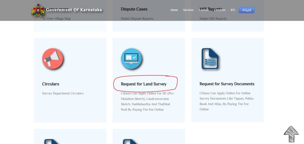
Step 1: Visit the official website: bhoomojini.karnataka.gov.in
Step 2: Scroll down and click on the “Request for Land Survey” option.
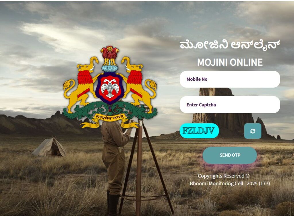
Step 3: Log in to the application by entering your mobile number and OTP.
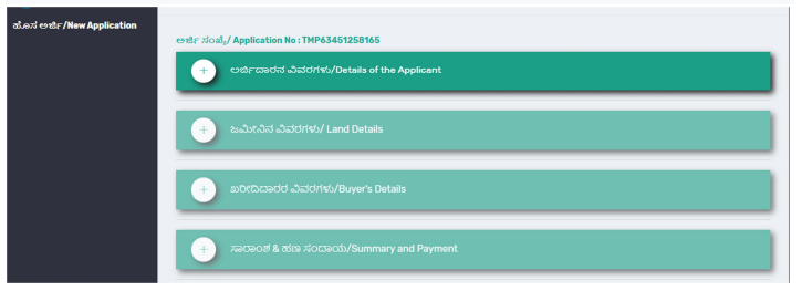
Step 4: Click on the “New Application” button and then click on the “Details of the Applicant” to fill in the details.
Step 5: Select the type of service & fill in the required information.
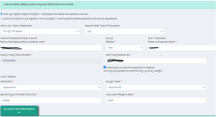
Note: Name as in Aadhar and name in RTC should match.
Step 6: After entering the information, click on the “Go to Next Section” button. Now, Applicant details will be saved, and you can move to the next section
Step 7: Click on land details and fill in the details. Enter the survey number details. Select the district, taluk, hobli, and village. Enter the survey number and select the hissa.
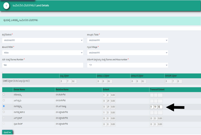
If it is sale sale-type of application, then need to enter the seller’s details.
Step 8: Click on the “Next” button. Now land details will be saved, and you can move to the next section.
Step 9: Click on the Buyers details and fill in the information. Click on the “Add buyer details” button.
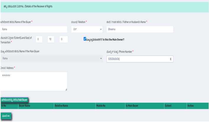
After entering the details, click on the “Next” button. The buyer’s details are saved, and you can proceed to the next section.
Step 10: Click on “Summary & Payment”. Now, click on the Pay button to pay the fee.

Step 11: Click on the check box and then click on the Pay now button.
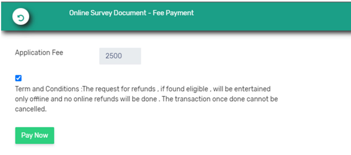
Select your preferred payment method from the available options.
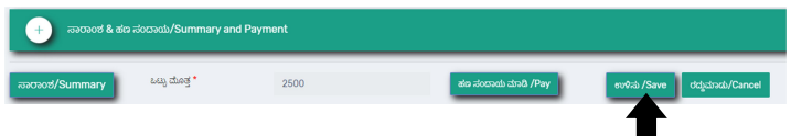
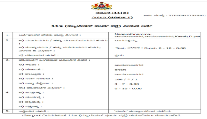
Step 12: After the successful payment, you will be back to rd services site. Now, click on the save button to get the acknowledgment.
You will get the acknowledgement as shown below.
Required Documents
Identity Proof: Valid government-issued photo identification such as Aadhaar card, voter ID, passport, or driving license. This document must match the name on the land records.
Property Ownership Documents: Sale deed, gift deed, or inheritance documents that establish your legal ownership of the land. These documents should clearly show your name as the current owner.
Existing Land Records: Current RTC (Record of Rights, Tenancy and Crops) or Pahani extract showing the present status of the land. This helps surveyors understand the current recorded details.
Previous Survey Documents (If available): Copies of any previous survey documents, sketches, or measurements related to the property. This provides historical context for the new survey.
Address Proof: Recent utility bill, bank statement, or any other document that confirms your current residential address
Fees and Payment Procedure
The fee structure for land surveys in Karnataka varies based on the location, type of survey, and land area.
Rural Area Fees
For rural areas, the fee for land survey in Karnataka typically ranges between ₹800 to ₹2,500 for properties up to two acres per application. For lands extending beyond two acres, an additional fee of ₹200 per acre applies.
Urban Area Fees
Urban area surveys generally have higher fees due to the complexity and higher property values. The exact fee depends on the specific urban area and survey type.
Additional Charges
Specific survey services may have additional charges, including ₹35 for measurement fees and ₹25 for notice fees for every adjacent landowner in certain cases. Some complex surveys may attract additional technical charges.
Payment Methods
The Mojini V3 platform accepts multiple payment methods for convenience, including online banking through major Indian banks, credit and debit cards (Visa, MasterCard, RuPay), UPI payments through various apps, and digital wallets where applicable.
After successful payment, you will receive a payment confirmation receipt. Save this receipt as proof of payment and for future reference during the survey process.
Help Desk Number
| Divisions | Contact Number |
| Mysore Division | +91 8277864065 |
| Banglore Division | +91 8277864067 |
| Kalaburgi Division | +91 8277864068 |
| Belagavi Division | +91 8277864086 |
Frequently Asked Questions
How long does it take to complete a land survey after applying through Mojini V3?
The timeline typically ranges from 15 to 45 days, depending on the complexity of the survey, weather conditions, and workload of the survey department.
Can I apply for a land survey if there is an ongoing dispute about the property?
Yes, land surveys can be requested for dispute resolution purposes. However, you should inform about any ongoing disputes in your application, and the survey may require coordination with all parties involved.
What happens if I need to modify my survey application after submission?
Minor modifications can usually be made by contacting the concerned survey office using your application number. Major changes may require submitting a new application.
Is the online survey request fee refundable if the survey cannot be completed?
Fees are generally non-refundable once the survey process begins. However, if the survey cannot be completed due to administrative reasons, you may be eligible for a refund or rescheduling.
Do I need to be present during the actual land survey?
Yes, property owners or their authorised representatives should be present during the survey to provide access to the land and clarify any questions the surveyor may have.
Can I request multiple types of surveys in a single application?
It’s generally better to submit separate applications for different types of surveys to ensure each requirement is properly addressed and tracked.